 Last month scientists announced that they’d identified a close match for dinosaur tracks found in the rocks of northern Cameroon…in Brazil, almost 4000 miles across the Atlantic Ocean! The footprints are about 120 million years old and include tracks from theropods (relatives of Tyrannosaurus), ornithopods (relatives of Hadrosaurus), and sauropods (relatives of Apatosaurus). Both sets of tracks, made when dinosaurs traversed the muddy surfaces near ancient streams and lakes, are preserved in the same sorts of sediments. In fact, the African and South American tracks are so similar that scientists think that they represent two halves of the same path, along which dinosaurs dispersed. How could a walking route that began in Africa ever wind up in South America? A look at Earth’s geologic history provides the answer…and illustrates the nature of scientific theories like evolution.
Where's the evolution?
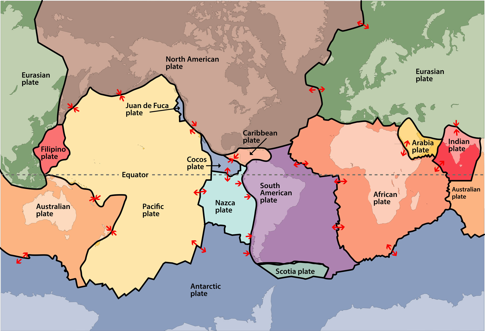
Today, the continents of Africa and South America are separated by an entire ocean, making a walk between them impossible. But that wasn’t always the case. Over at least the last 2.5 billion years, the parts of Earth that are exposed as land have shifted as sea levels have risen and fallen, and as Earth’s crust has reconfigured and remade itself through plate tectonics. The theory of plate tectonics proposes that the rocky outer layer of the Earth is composed of a series of gigantic plates that fit together like a jigsaw puzzle. These plates slide (very, very slowly!) over the layer beneath them. Where the plates move towards one another, they may collide and push both plate edges up, forming a mountain range (the Himalayas formed this way), or one plate may slide underneath, lifting the other plate up (the Andes formed this way) and forcing the lower plate down to be melted into magma. Where the plates move apart, lava flows up and forms new crust, building on the edges of the two plates.
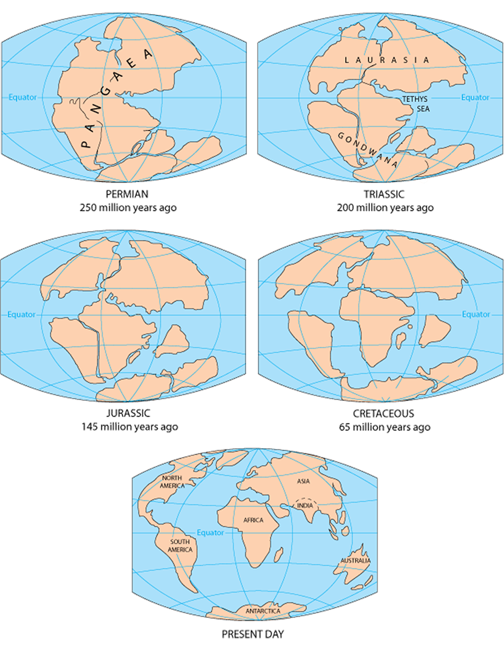
Through billions of years of incremental plate movement, Earth’s exposed landmasses have migrated around the globe, cycling through periods in which they converge into a single supercontinent and then break up again into multiple distinct continents. Earth’s most recent supercontinent, known as Pangaea, existed from about 335 million years ago until 200 million years ago, when it began to break apart. First, it split into two landmasses (shown on the second map below). Laurasia was composed of modern-day north Asia, Europe, and North America, and Gondwana was made up of modern-day South American, Africa, Antarctica, India, Australia, and Arabia. By 120 million years ago, when the dinosaur trackways were laid down, Gondwana had broken up a bit, but South America was still tucked into the hollow of Africa (as shown on the third map below) – and so land comprising modern-day Brazil abutted that which we now recognize as Cameroon. Land animals would have been able to walk from one to the other.
Finding matching dinosaur footprints in Cameroon and Brazil makes perfect sense in light of the theory of plate tectonics. Indeed, when Alfred Wegener proposed the idea that the continents are mobile more than 100 years ago, he marshalled just this sort of evidence to make his case. He argued that the distribution of a wide range of organisms – including earthworms and the fossils of an extinct tree – all fit with the idea that continents move.
Of course, scientific theories that become widely accepted, as plate tectonics and evolution have, aren’t supported by just one line of evidence. These theories are supported by and help make sense of a wide range of phenomena and observations. Wegener, for example, pointed out that the idea that Earth’s continents had all once been joined together also helped explain their shapes, the distribution of coal deposits and other geologic features, and the evidence suggesting that the ancient climates of Earth’s landmasses differed substantially from those of today. Evidence collected decades later showed that plate tectonics also explains the patterns of magnetic polarity recorded in Earth’s rocks. And still later, when underwater mountain ranges in the middle of the ocean and seafloor spreading were discovered, it all made sense if plate tectonics were true. Today, satellites can measure exactly how much and how fast Earth’s continents are moving. The theory of plate tectonics is supported by and helps explain all these diverse lines of evidence; they all fit. The same is true of evolutionary theory. The genetic sequences of different organisms, their physical and behavioral traits, the fossil record, and a wide variety of experimental results, all make sense if different species share common ancestors and diverged through evolutionary processes like natural selection.
Explaining a wide range of phenomena is part of what makes plate tectonics and evolution good theories, as opposed to good hypotheses. In casual conversation, we might use the words theory and hypothesis interchangeably to mean a guess. But in science, hypotheses and theories are not mere guesses. They are potential scientific explanations, usually based on prior experience, background knowledge, observations, and logical reasoning, that differ in scope. Hypotheses apply to a fairly narrow set of phenomena, while theories are broader explanations that integrate and generalize many hypotheses.
To be accepted by the scientific community, theories must be supported by many different lines of evidence, and they must continue to explain new evidence and make new predictions that hold true. When the scientists behind the dinosaur track research dated the Cameroonian prints to 120 million years old – a time when our understanding of plate tectonics tells us that Africa and South America were still part of the same landmass – they wondered if these prints might be related to South American dinosaur footprints they’d heard about. As we’ve just seen, a little more digging revealed that they are closely connected, despite the long flight that separates them today.
Primary literature:
- Jacobs, L. L., Flynn, L. J., Scotese, C. R., Vineyard, D. P., and De Souza Carvalho, I. (2024). The Early Cretaceous Borborema-Cameroon dinosaur dispersal corridor. New Mexico Museum of Natural History and Science Bulletin. 95: 199-212. Read it »
News articles:
Understanding Evolution resources:
Understanding Global Change resources:
Understanding Science resources:
- What new discovery is summarized in the article above?
- What is the likely explanation for the similarities between the Cameroonian and Brazilian tracks?
- Describe three lines of evidence that the theory of plate tectonics helps explain.
- Do some research online to find and describe another example (not mentioned in the article above) of how the geographic ranges of modern organisms (or of the localities of fossils) are explained by plate tectonics.
- Do some research online to find and describe one example of a scientific hypothesis and one example of a scientific theory (neither given in the article above) that illustrate their difference in scope.
- Advanced: Imagine that a friend says, “I’ve got a theory about why my phone keeps dying,” and goes on to explain they use a lot of apps that require GPS and location services. In what ways does this use of the word theory align with its meaning in science and in what ways does it differ?
- Teach about geologic time: In this web-based module, primary, middle, and high school students gain a basic understanding of geologic time, the evidence for events in Earth's history, relative and absolute dating techniques, and the significance of the Geologic Time Scale.
- Teach about scientific theories: In this quick activity for high school and college, students engage in a structured discussion that clarifies the scientific meaning of the term theory.
- Teach about scientific vocabulary: In this activity for high school and college, students conduct a survey about the nature of science, laws, theories, hypotheses, scientists, and evolution.
- Jacobs, L. L., Flynn, L. J., Scotese, C. R., Vineyard, D. P., and De Souza Carvalho, I. (2024). The Early Cretaceous Borborema-Cameroon dinosaur dispersal corridor. New Mexico Museum of Natural History and Science Bulletin. 95: 199-212.
- Wegener, A. (1924). The origin of Continents and Oceans. Translated by J. G. A. Skerl. E. P. Dutton and Company, New York. Retrieved September 17, 2024 from Wikisource